
 Culture and entertainment
 Supermarket
 Business and services
 Collectibles and art
 Home & garden
 Kids
 Electronics
 Computers
 Automotive
 Tools
 Fashion
 Sports & travel
 Phones & accessories
 Health & beauty
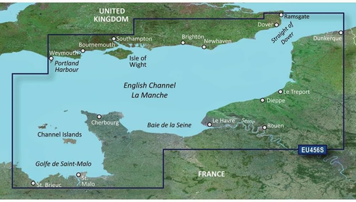

Garmin BlueChart g2 VEU456S - The Solent and Channel Islands chart
Garmin BlueChart g2 VEU456S - The Solent and Channel Islands chart www.KupCoChcesz.pl
Orders placed by 1:00 PM are shipped the same business day. U Ciebie pojutrze!
Availability: high stock
Dispatched within:
24 hours
Share: 


Opis
Garmin BlueChart g2 VEU456S - The Solent and Channel Islands chart
The VEU456S card is a Garmin BlueChart g2 electronic marine chart for a chartplotter. It covers part of the coast of Great Britain and northern France, making it useful for sailors cruising the English Channel.
Chart coverage
On the British side, the chart covers the coast from Newhaven to Portland Harbour, including the Solent strait and the Isle of Wight. On the French side, coverage extends from Arromanches-les-Bains to Saint-Brieuc, including Saint-Vaast-la-Hougue, Cherbourg, Saint-Malo and the Channel Islands.
Use
The chart is intended for compatible Garmin chartplotters that support BlueChart g2 cards and allows precise planning of sailing routes in this area, including harbor approaches and strait crossings. Detailed depth data and navigation markings make it easier to pilot a vessel safely on both the English and French sides of the Channel. The card comes as a physical microSD/SD medium and simply needs to be inserted into the appropriate slot of the plotter, with no extra software installation.
Specifications
| Catalog number | 010-C0800-00 |
| Manufacturer | Garmin |
| Format | microSD/SD card |
| Region | Great Britain (English Channel) and northern France |
Product reviews
Ask a question
We will send the answer to your e-mail address.
Similar products








Own this product?
Rate Garmin BlueChart g2 VEU456S - The Solent and Channel Islands chart and help others choose.
Add a reviewCustomer reviews (0)
This product has no reviews yet — yours could be the first.
Add a review
Sign your name and write a few sentences about the product.