
 Culture and entertainment
 Supermarket
 Business and services
 Collectibles and art
 Home & garden
 Kids
 Electronics
 Computers
 Automotive
 Tools
 Fashion
 Sports & travel
 Phones & accessories
 Health & beauty
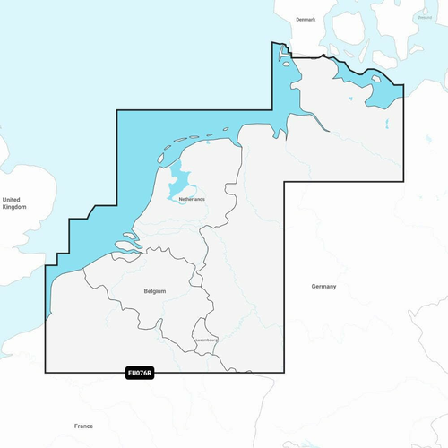

Garmin Navionics+ EU076R - map of Benelux and western Germany
Garmin Navionics+ EU076R - map of Benelux and western Germany www.KupCoChcesz.pl
Orders placed by 1:00 PM are shipped the same business day. U Ciebie pojutrze!
Availability: high stock
Dispatched within:
24 hours
Share: 


Opis
Garmin Navionics+ EU076R - map of Benelux and western Germany
The Navionics+ EU076R card is a Garmin electronic marine chart covering the waters of the Benelux and western Germany. It is intended for compatible Garmin chartplotters and combines coastal and inland cartography in one product, making it easier to plan routes that join sea stretches with navigation on the rivers and canals of this region.
Mapping features
The chart combines detailed SonarChart HD bathymetric data with route planning tools that suggest paths based on boat settings and chart data. It also supports the Community Edits layer, showing local information uploaded by other boaters.
Updates
The content of the Navionics+ card can be updated by downloading new data through Navionics software on a computer or wirelessly via the Navionics Boating app, if the plotter supports synchronization. The card in microSD/SD format just needs to be inserted into the slot of a compatible plotter to get immediate access to cartography covering the whole region.
Specifications
| Catalog number | EU076R |
| Manufacturer | Garmin |
| Region | Benelux and Western Germany |
| Format | microSD/SD card |
| Weight | 250 g |
| Warranty | 2 years |
Product reviews
Ask a question
We will send the answer to your e-mail address.
Similar products

Own this product?
Rate Garmin Navionics+ EU076R - map of Benelux and western Germany and help others choose.
Add a reviewCustomer reviews (0)
This product has no reviews yet — yours could be the first.
Add a review
Sign your name and write a few sentences about the product.