
 Culture and entertainment
 Supermarket
 Business and services
 Collectibles and art
 Home & garden
 Kids
 Electronics
 Computers
 Automotive
 Tools
 Fashion
 Sports & travel
 Phones & accessories
 Health & beauty
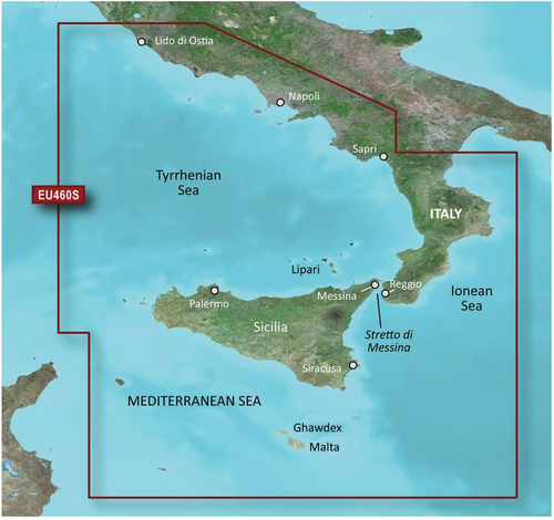

Garmin BlueChart g2 HXEU460S – map card Sicily–Lido di Ostia
Garmin BlueChart g2 HXEU460S – map card Sicily–Lido di Ostia www.KupCoChcesz.pl
Orders placed by 1:00 PM are shipped the same business day. U Ciebie we wtorek!
Availability: high stock
Dispatched within:
24 hours
Share: 


Opis
Garmin BlueChart g2 HXEU460S – map card Sicily-Lido di Ostia
The BlueChart g2 HXEU460S card is electronic marine cartography in microSD format with an included SD adapter, intended for Garmin chartplotters that support the BlueChart g2 format. The coverage includes the coast of the Tyrrhenian Sea from Sicily to the area around Lido di Ostia, which is a stretch of coast near Rome.
What the cartography includes
The map presents detailed navigation data typical of nautical charts, including IALA navigation marks, depths and points important for coastal navigation. The map view can be switched between the classic top-down layout and a perspective view, which makes orientation easier both when planning a route and during the cruise itself.
Compatibility
The card fits only Garmin chartplotters that support BlueChart g2 cartography - before buying, it is worth checking whether your chartplotter model accepts this specific card format. The medium is a microSD card with an included SD adapter, which makes it easier to back up the data on a computer.
Specifications
| Part number | 010-C0804-20 |
| Format | microSD + SD adapter |
| Map coverage | Sicily - Lido di Ostia (Tyrrhenian Sea) |
| Cartography | Garmin BlueChart g2 |
Product reviews
Ask a question
We will send the answer to your e-mail address.
Similar products





Own this product?
Rate Garmin BlueChart g2 HXEU460S – map card Sicily–Lido di Ostia and help others choose.
Add a reviewCustomer reviews (0)
This product has no reviews yet — yours could be the first.
Add a review
Sign your name and write a few sentences about the product.